
Karst & Water
Crawford County sits upon an abundant aquifer. Cold springs bubble up from hillsides. Trout streams appear, dive underground, and reappear a mile away. Wells tap an aquifer that has been building for thousands of years. Caves hold underground rivers that no one has fully mapped.
This is karst — a landscape shaped over 500 million years by water slowly dissolving carbonate rock into a hidden network of fractures, caves, sinkholes, and underground channels. It gives us our cold springs and native trout streams. It is also what makes this place unlike almost anywhere else.
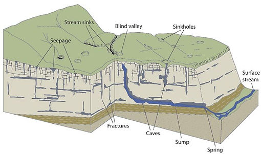

The same system that moves water so beautifully also moves it fast. In most landscapes, groundwater filters slowly through soil and porous rock, taking years to reach an aquifer. Here, it can travel from the surface to a spring or a well in hours, through channels that bypass natural filtration. What happens on the land matters directly and immediately to the water that emerges downstream or from someone's tap.
We are stewards of something rare. Crawford Stewardship Project has spent nearly two decades trying to understand it, map it, and make sure our community has the information it needs to take care of it.
Driftless Area Water Study
(DAWS)
For years, locals have boasted about the water here. With good reason — much of it is genuinely exceptional. But until recently, less than 1% of wells in Crawford County had ever been tested. We loved our water without knowing what was in it.
Crawford Stewardship Project decided to find out. Starting with a small pilot in 2019, CSP worked with county Conservation and Health Departments and the UW-Stevens Point Water and Environmental Analysis Lab to build something larger. In 2020, the Driftless Area Water Study launched — a tri-county collaboration between Crawford, Richland, and Vernon Counties to test private wells and build a real picture of regional groundwater quality.
In 2026, we completed the largest round yet: 352 wells tested across three counties, including a full panel of metals — arsenic, lead, uranium, and more — alongside nitrates and bacteria.
What we've found:
-
Most people here are drinking safe water. Results vary across the region, shaped by well construction, local land use, and the underlying geology.
-
Hard water is standard: High mineral content from our limestone bedrock is great for the trout and our taste, but tough on appliances.
-
Nitrate trends: Nitrates are natural at low levels, but are a health risk at high levels. In 2026, DAWS found 27% of wells with no detectable levels, 4% above the health standard of 10mg/L, and four wells over 20mg/L, more than double the health standard. Great news for some, a health hazard for a few, and the rest of us falling somewhere in between.
-
Bacteria presence: Roughly 11% of wells showed coliform bacteria, and two wells tested positive for E. coli.
-
Your role matters: Proper well construction, regular inspection, maintenance, and testing are important to prevent, identify, and resolve issues.
-
The greatest finding is that we are still only scratching the surface — more data means better understanding!
Test your well:
The DAWS project group website: Driftless Area Water Study — Vernon County

2026 DAWS Results Public Events
- Crawford: Testing the Waters - Driftless Area Water Study Results 2026Sat, Jun 27Gays Mills Community Commerce Center
- Richland: Testing the Waters - Driftless Area Water Study Results 2026Thu, Jun 25Richland Center Community Center
- Vernon + Virtual: Testing the Waters - Driftless Area Water Study Results 2026Tue, Jun 09Viroqua & Virtual
Karst Explorations & Education
The best way to understand karst is to get into it.
For fourteen years, Crawford Stewardship Project has led annual Karst Explorations — guided field trips into the springs, caves, and sinkholes of Crawford County. Each year features a different route and different expert presenters. Some years we explore caves. Some years we wade through springs. All are family-friendly and free.
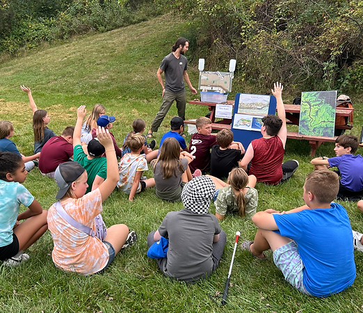
We also bring karst into the classroom. CSP offers adaptable presentations on karst geology, groundwater, and local water quality for school groups from elementary through university level, and we appear annually at Crawford County Youth Conservation Days.
Watch for our 2026 Karst Exploration in August at Sugar Creek Bible Camp — check the Events page for details.
Want a presentation for your school, civic group, or organization? Contact us: contact@crawfordstewardship.org
Civic Science & Mapping
Good stewardship requires good information. Over the years, CSP has worked with scientists, volunteers, and county partners to build a more complete picture of the karst landscape beneath Crawford County.
Our sinkhole mapping project trained community volunteers to identify and document karst features across the county. That record is now used by Crawford County when evaluating permit applications for large-scale projects. When someone proposes siting a major installation here, that map is part of how the community asks: does this make sense, given what's underground?
Our well construction report analysis turned the records of every well drilled in Crawford County into data. The finding: in areas underlain by carbonate bedrock, there is a 28% chance that any given borehole will hit an underground karst feature — a void, a cave, a crevice. That figure matters for wells, for infrastructure, for anything going into the ground in this county.
We're also working with regional partners to advocate for updated bedrock studies in southwestern Wisconsin — the kind of rigorous geological survey that our neighbors to the south received through the Southwest WI Groundwater & Geology Study, and that our equally complex landscape deserves.
Explore the CSP Karstology Viewer — interactive maps of karst features, bedrock geology, LiDAR imagery, and groundwater susceptibility for Crawford County.
Resources
Listen: "A Leaky System" — featuring CSP's Forest Jahnke on karst geology and groundwater → SoundCloud
Watch: Eric Carson on the geology of the Kickapoo Valley Reserve → YouTube
Explore: Wisconsin Geological and Natural History Survey — karst and sinkholes → wgnhs.wisc.edu
UWSP Wisconsin Well Water Quality Viewer → Well Water Viewer
CSP Karstology Viewer → karstology.crawfordstewardship.org
Karst posters — illustrated karst posters, $10 each (plus shipping). Good for classrooms, offices, or anyone who loves this place. → contact@crawfordstewardship.org